Alice Springs Maps
On this page you can find several Alice Springs maps:
Overview maps of where Alice Springs is located in Australia, an interactive map that lets you zoom in close enough to see cars and buildings, and some free, printable maps of Alice Springs.
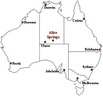
The first map shows where Alice is located in Australia: exactly in the middle.

Here is a map of the Northern Territory, showing the roads to and from Alice Springs, and the roadhouses.
Map of Alice Springs, Northern Territory
This is another one, showing more detail of the area around Alice Springs.
Map of Alice Springs and Central Australia
Interactive Alice Springs Map
Use the arrows to move around, and the (+) and (-) buttons to zoom in and out.
This is the most detailed map of Alice Springs available. Zooming in lets you read all the street names. If you switch to satellite view or hybrid view (hybrid gives you the satellite image overlaid with the map) you can even see buildings and cars on the streets!
(Satellite and hybrid view is not recommended for dial up users. It takes way too long...)
Printable Alice Springs Maps
And last but not least, here are links to free, printable maps of Alice Springs, available on the Central Australian Tourism site:
(These Alice Springs maps are .pdf documents and you need Adobe Acrobat reader to view and print them. If it's not installed on your computer get it here for free.)
- (You may need to play with your printer settings to get this printed on two pages or it may be too small to read.)
A map of the Alice Springs area. (This is an excellent regional map showing all the national parks and tourist attractions near Alice Springs, including Ayers Rock, and all the distances in km.)
Return to Alice Springs, Australia index
Return from Alice Springs Map to Outback Australia Travel Guide home page


