Australian Outback Map
"So you'd like a map of the Australian Outback?"
"Australian Outback map" is one of the terms that many of you type into my search box.
I figured I better do something about the perceived lack of a map of the Outback. Though it's not easy...
How do I explain it? The Outback is kind of, well, more or less all of Australia...
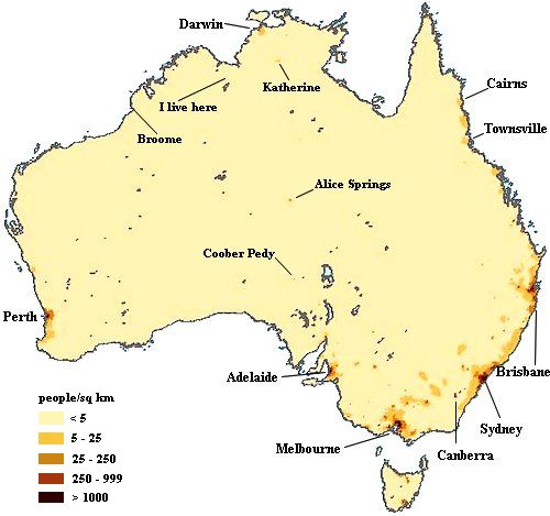
But, never one to shy away from a challenge, I did the best I could:
I made an Australian Outback map for you.
(My explanations are below it.)
A Map Of The Australian Outback

As I already said, a map of the Australian Outback is a map of Australia, there is no other way to show all of the Australian Outback.
Outback is a term that describes rural and remote areas in Australia, the parts where not many people live. The different colours in my Outback map show population density, and as you can see, most of Australia is rather empty...
(The map is actually a bit rough, because many of those areas showing < 5 people per km2 are inhabited by less than one person per km2.)
Most Australians live near one of the major Australian cities on the coast. The most densely populated part of Australia is the south-east. In your mind draw a line from Adelaide to Brisbane. Below and to the right of that line (roughly) is where most Australians live. You can see the darker areas in the map. Above and to the left is the Outback...
Now follow the east coast going north all the way to Cairns. The whole coast is fairly populated as well, but it is only a very narrow strip. Go inland just a few hundred kilometres, and you'll be in the Australian Outback for sure.
There is one more population centre on the west coast, the area around and south of Perth, that whole bulge in the bottom corner there, and a narrow strip along the coast going north, where you will find a few smaller towns.
And that's it. The rest of Australia is more or less empty! Everything else on the map is the Australian Outback. Even the area around Darwin in the north. Darwin is a city, but it's small and isolated. Step outside the city and you find yourself in the Outback. And places like Katherine or Alice Springs are but mere specks in the middle of nowhere... Definitely Outback.
Now, to give you an idea of the size of it all: Australia is about the same size as the US minus Alaska. Very roughly 4000 km top to bottom or west to east coast. You can't just go and see the Australian Outback, you can only ever go and see a small part of it, unless you visit us for at least several months. Keep in mind that the different parts of the Outback do not at all look the same, or even have the same climate....
So the first thing you have to decide is which part or parts of the Australian Outback you want to visit. (That's the hardest part because all of it is so darn beautiful...) Then get a good map of that part of Australia, and it will include the Outback areas as well.
The whole purpose of this site is to help you with those decisions. I want to show you as much as I can of all the different beautiful parts of the Australian Outback. (And there are more Outback maps sprinkled through the site that show details of the different areas.)
I hope the above Australian Outback map puts things into perspective for you. Just for fun I pencilled in where I live as well, as far away from any population centre as possible. You can't live much further out back...
It's beautiful here. Hope you come and visit one day...
Related articles:
- Where or what is the Australian Outback? This article introduces you to the main different areas of the Australian Outback.
- Cities and Towns in Outback Australia: the Sydney and Melbourne areas are as un-outback as it gets. If you want to see the real Australian Outback try flying into one of these places...
Find more articles and information about the Australian Outback
Return from Australian Outback Map to Outback Australia Travel Guide home page


