The Nullarbor Plain Or "Nullarbor Desert"
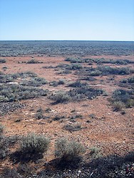
Photo by Sheilaellen
In a country where they just don't do small the Nullarbor Plain—also known as the Nullarbor Desert—manages to take it a step further. It breaks a number of world records.
Affectionately known by Australians as the Nullar-boring, it is believed to be a dried up sea bed. For all its lack of visual stimulation this is easy to imagine.
But scratch the dry surface and be prepared to unearth many legends, a rich history and stunning scenery along the 1200 km that makes the Nullarbor.
- Nullarbor Desert facts
- Nullarbor climate, vegetation and wildlife
- Crossing the Nullarbor Plain
- Things to see and do
- Planning around the roadhouses
Facts about the Nullarbor Plain
- The Nullarbor is officially the earth's largest piece of limestone (200 000 km2 and 1200 km from east to west at its furthest point) the Nullarbor Plain is the section of southern land between Norseman in Western Australia and Ceduna in South Australia.
- The name comes from the Latin for nothing (nullus) and tree (arbor).
- The region averages 200 mm of rain per year.
- The railway line boasts the longest straight section of railway in the world at 478 km. The impressive 146.6 km of tarred road surface holds the world record for straight length of road.
- From space it appears that a giant sea creature tried to take a bite out of the land between south and west Australia. Look a little closer and you will see flat, arid/semi-arid country almost completely devoid of trees.
- It is Australia's largest karst region (200 000 km2).
- The Nullarbor is a series of flat tiers formed under the sea. Crustal movements lifted the area and wind and rain smoothed it out.
- The British used this area to do nuclear tests at Maralinga in the 1950s forcing many of the Wangai to leave.
- The Nullarbor Nymph was a publicity stunt in the early 1970's. Reports (including grainy amateur film) of a woman living half naked amongst the kangaroos on the Nullarbor Plain had everyone wondering and the small town of Eucla (population 8) overrun by journalists.
- Balladonia is close to where Skylab crashed to earth in 1979.
- Many meteorites have also been discovered here. Especially around Mundrabilla some weigh tonnes and they are all very well preserved due to the arid climate.
- When you pass through Kimba you are half way across Australia.
- A substantial area of the Nullarbor Plain has been declared a national park.
Nullarbor Desert Climate, Vegetation and Wildlife
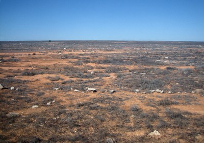
Photo by Sheilaellen
As you would expect from a desert the Nullarbor has arid to semi-arid conditions and extreme temperatures. Rainfall averages around 200mm per year. The days can see temperatures nearing 50°C (even though the average daily max in summer is only 25°C!) and nights can be freezing.
The average night temperatures range from 7°C in winter to 17°C in summer.
As the name indicates (Nulla-arbor = zero trees), there aren't any trees. The sparese vegetation consists of low saltbush and blue bush scrub.
Camels don't need much and you may well come across one or the other on your trip. Another occasionally spotted nullarbor resident is the dingo. Southern right whales can bee seen when they visit their winter calving grounds, from May to September.
Crossing the Nullarbor
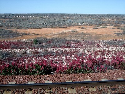
Photo by Sheilaellen
Everyone has their own reason for crossing the Nullarbor. Edward John Eyre summed it up with his words and actions back in 1841. Soon after being publicly quoted as saying "a hideous anomaly, a blot on the face of Nature, the sort of place one gets into in bad dreams", he promptly proceeded to cross it anyway!
By road
If there are no trees or hills, the shortest way from A to B is definitely direct. Across the southernmost part of the Nullarbor Plain stretches the longest straight road in the world.
The first motorcar crossed the Nullarbor Desert in 1912. The modern road is tarred and you know you will be battling with boredom, heat, cold... and yourself as it is a long time to spend in your own head.
The road is called the Eyre Highway (named for John Eyre who crossed the Nullarbor Plain in 1841) and connects Norseman in Western Australia with Port Augusta in South Australia, a distance of 1675 km.
There is a roadhouse every 200 km or so, so there's nothing to worry about. You can get accommodation in several places and there are many opportunties for free camping as well.
This highway is also a major truck route which means that someone will be along sooner rather than later to rescue you if you break down! Driving across the Nullarbor Desert is neither a challenge nor a big adventure these days, just a very long drive. (See below for suggestions how to break up the drive.)
By rail
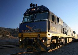
Photo by Rob & Jules
The Indian Pacific crosses the Nullarbor Plain from Perth to Sydney via Adelaide, twice weekly in both directions.
The full journey covers a distance of 4352 km and lasts three nights.
This is the most direct route across the Nullarbor Desert, running between Kalgoorlie and Port Augusta. When the scenery starts living up to its press you can always bury your nose in a book.
"Whistle stop tours" include a free one hour tour of historical Cook (population 4), the only stop on the Nullarbor Plain itelf.
Fares start from $690 for the whole distance, or from $395 for the Nullarbor only (Adelaide—Perth).
By bicycle
Yes, you could cycle the Eyre Highway. It has gained international respect as a cyclists challenge. Alternatively you can simply pack your bicycle, plenty of water, some insect repellent and cycle the Westall Way ring road (9km south of Streaky Bay).
Running or Walking the Nullarbor Plain
A stroll across this great plain is generally done to prove something or highlight a cause but it can and has happened.
Exploring the Nullarbor Plain OFF the road
The Gawler Ranges - This entire area is only suitable for fully equipped 4x4 explorations. You can travel from Iron Knob to Wirrulla via Mount Ive through the Gawler Ranges.
The Mount Wudinna Recreation Reserve and Turtle Rock can be accessed along Route 63. Indulge in a number of short bush walking tracks or maybe you want to get to the top of Mount Wadena? There are excellent picnic spots and this is a great idea if you would like to explore along very well maintained dirt roads.
What to see and do on your Nullarbor Crossing
The Inselbergs:
- Ucontitchie Hill (An inselberg of international geological significance) can be found 30 kilometers south of Wudinna along a well maintained dirt road. You will pass through a number of farm gates - please be courteous and leave them as you found them.
- Murphy's Hay Stacks (also inselberg formations) are around 100,000 years old and these pink granites were originally formed 7 to 10 kilometers below the surface. Today they are located 40 kilometers southeast of Streaky Bay along sealed roads.
- Pildappa Rock is found 20 kilometers from Minnipa and is part of the Gawler Ranges. The Pildappa Rock was formed 1500 million years ago and its unique wave or flare structure which stands 2 to 3 storey's tall is attributed to complex chemical weathering underneath the surface.
Westall Way has a huge variety of land and sea on offer. From cliffs to boulders and granite pools to sand hills.
- High Cliff reaches into the sea and you can reach it from Tractor Beach or The Granites which has excellent camping facilities.
- Smooth Pool is an eroding granite shelf and a beautiful spot for combining a picnic with photography. At low tide the rock pools will produce crabs, fish, seaweeds, barnacles and starfish. Remember sturdy walking shoes.
Denial Bay will delight seafood aficionados. The blue swimmer crab attracts Japanese tourists by the bucket full as they try their hand at "crabbing". If you take a break from catching crabs make sure you try some fresh Pacific Oysters.
If you happen on the Nullarbor between June and October and find yourself 78 Kilometers west of Yalata and 20 kilometers east of Nullarbor Roadhouse you have to stop! The Head of Bight is your best chance ever of spotting a Southern Right Whale.
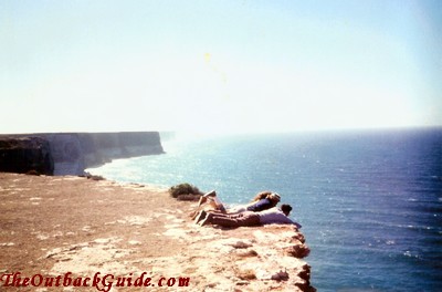
The Bunda Cliffs hosting the spectacle of whales stretch in an unbroken line for 200 kilometers and reach heights of 70 to 90 meters.
The Murrawijinie Caves are one of the few areas where the southern ocean blows through subterranean caves creating blow holes that are open to the public. Around 10 km north of the Nullarbor Roadhouse you will need exact direction and a sturdy 2 wheel drive car to reach them!
Cocklebiddy is where you will find the largest of all the Nullarbor Caves (explored to a distance of over 6.4 kilometers) as well as Twilight Cove located to the south were the limestone cliffs tower over 70 meters.
The historical Eucla Telegraph station (est. 1887) is surrounded by shifting dunes.
Planning around the roadhouses
Nundroo Roadhouse - Check the oil and water!
Wheat and sheep paddocks line the road on the way to this roadhouse. This is also the last mechanical repair shop until Norseman which is over 1000 km away.
Yalata Roadhouse - Retail therapy.
The very best the Nullarbor has to offer. It also boasts fantastic deals on Aboriginal paintings and carvings.
Nullarbor Roadhouse - Plan for major sightseeing.
The only bump on the treeless windswept plain. Also the best base for seeing the most impressive and renowned Nullarbor sights. You can board a flight here for a superb view of the Bunda Cliffs, the Head of Bight and hopefully some Southern Right Whales.
Mundrabilla Roadhouse - Spot some truckies.
Filled with road trains this basic roadhouse is more popular with truckies.
Madura Roadhouse - Spot some tourists.
This is where the tourists stop and this roadhouse has a scenic and peaceful aura.
Cocklebiddy Roadhouse - Imagine you are a great explorer.
You can simply treat this as a rest or use the stop to explore the nearby caves and Twilight Cove.
Caiguna Roadhouse - Catch up on a bit of history.
Visit the Caiguna Blowhole and the Baxter Museum
Balladonia Roadhouse - Prepare for civilisation.
Not very far from this pub Skylab crashed to earth in 1979. It is popular myth that NASA has been presented with a refuse fine by local government. The place offers a reintroduction to civilisation by offering cappuccinos, uniformed staff and high prices!
Books to take on your Nullarbor journey
Bolam, A. G. (Anthony Gladstone many editions in the early 20th century, 1893-1966. The trans-Australian wonderland Melbourne
Edmonds, Jack (1976) Nullarbor crossing : with panorama photographs by Brian Gordon. (Perth, West Australian Newspapers, Periodicals Division. ISBN 0909699097)
Fuller, Basil (1977) Nullarbor lifelines
Jill (1989) Verse from the Nullarbor Campbell
Dyer, Colin & Gilbert, Henri (1996) A Frenchman's walk across the Nullarbor: Henri Gilbert's Diary, Perth to Brisbane, 1897 1899
Mariette, (1987) The Nullarbor Witch
Fuller, Basil (1972) The Nullarbor Story
Casanova, Jack (1996) When grass was gold: South Australia's reach to the Nullarbor
Idriess, Ion (1951) Across the Nullarbor. A Modern Argosy
Read about other Australian Deserts
Return from Nullarbor Plain to Outback Australia Travel Guide home page


