Kakadu Attractions - Things to Do in Kakadu
On this page I have listed all the main tourist attractions, the walks and lookouts, and ideas for things to do within Kakadu National Park.
The page is organised by area to help you plan your trip. We start at the Northern Entry Station, as this is the entry you will reach if you come from Darwin.


Following the Arnhem Highway we traverse the first three areas to get to the far end of the park. From there the Kakadu Highway leads through the remaining four areas to exit the park via the Southern Entry Station and return to the Stuart Highway.
(You can find several maps of Kakadu here.)
From there you can return to Darwin, via Litchfield National Park if you like, or continue to Katherine and the beautiful Katherine Gorge National Park.
All access is 2WD, and generally open all year, unless I state otherwise. All turn offs and attractions are signposted. It's easy to find your way around. I think it's actually impossible to get lost in Kakadu National Park...
Kakadu - South Alligator Area
The main attraction of this area are the Mamukala wetlands. You will reach the turn off about 65 km past the entry to the park. A short track leads to an observation platform on the edge of the wetlands.
The wetlands are beautiful all year round. If you have the time you can take the 3 km walk to explore Mamukala further.
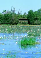 But Mamukala is at its most spectacular towards the end of the dry season (Sep/Oct), when the diminishing water resources cause thousands of birds to congregate there.
Within the shady observation platform you seem to sit right in the middle of them.
Murals and paintings inside the hide explain the changes of the wetlands during the seasons and give you information about the many different bird species that you see. It's a relaxing and peaceful place to sit, enjoy the cool breeze, take photos and listen to the birds' conversations.
Other attractions in this area:
- Gu-ngarre walk: The starting point lies 10 km before the Mamukala turn off, near Aurora Kakadu Resort. This 3.6 km walk will take you through woodland, monsoonal forest and along the edge of Anggardbal billabong.
- The South Alligator picnic area turn off lies between Gu-ngarre and Mamukala. Here you find picnic and barbecue facilities and a boat ramp.
Further destinations for boating and bird watching can be found along the two 4WD tracks in this area.
- Waldak Irrmbal near the entry station takes you to Two Mile Hole, Four Mile Hole and the West Alligator Head.
- Birdwatchers can explore the shorter track to the Red Lily, Bucket and Alligator Billabongs. Both tracks are impassable during the wet season.
Kakadu - Jabiru Area
Jabiru is actually a town within Kakadu National Park. Here you will find many services like a supermarket, post office, bank, chemist, accommodation and more. Jabiru East Airport is only 4.5 km away, and many tourists access Kakadu that way.
Scenic flights and commercial tours starting here can be booked through the Jabiru Travel Centre, +61 8 8979 2548.
Jabiru is more of a strategic centre and a good starting point for an in depth exploration of Kakadu than it is an attraction in itself.
The one real attraction in this area is the Bowali Visitor Centre. I can't think of a better place to learn about Kakadu. It contains extensive displays, videos, a library, free maps and information sheets, and also a cafe and a gallery with Aboriginal arts and carts. The cafe and gallery are open from 9 am to 5 pm.
Actually, the whole visitor centre is an artwork in itself. Every detail of the building and everything it contains is lovingly crafted... Don't miss it, allow a few hours to spend there, you will get a lot more out of the rest of your visit if you do.
While you're there make sure to grab a copy of the free "What's On?" guide. It gives you the times and locations of the many free guided walks and talks that are available.
You can also download it here: Free guide to "What's On" in Kakadu, 2012.
(Downloadable PDF. The link will open a new window. After you have downloaded the guide just close the window to return here.)
Kakadu - East Alligator Area
A visit to the East Alligator Area requires a 40 km side trip off the Arnhem/Kakadu Highway intersection. This will take you to the border between Kakadu National Park and Arnhem Land. (At over 96,000 sq km Arnhem Land is the largest Aboriginal reservation in Australia. It can only be accessed with a permit or on a guided tour.)
The border store sells diesel and petrol, food and fishing gear, and also takes bookings for commercial tours: +61 8 8979 2474 (services may be unavailable Nov - April). Near the store you find Cahills Crossing picnic area with tables and a viewing platform over the river.
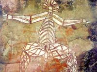 The main attraction in this area is Ubirr rock. On a 1 km circular walk you can visit some of the most fascinating Aboriginal rock art sites.
To make the most out of your visit join one of the free talks on Aboriginal art and culture that are given by the rangers. The "What's on" guide available at the Bowali Visitor Centre will provide you with details.
A 250 m climb takes you to the top of the rock, where you are rewarded with breathtaking views over the Nardab floodplains and Arnhem Land. The views are particularly beautiful at sunset. I have seen tour groups enjoy beers and other "sundowners" on top of the rock and understand the desire to do so. But I ask you to respect the request of the Aboriginal owners that you don't drink alcohol at Ubirr.
Other attractions:
- The East Alligator River forms the boundary between Kakadu and Arnhem Land. Commercial cruises are available, and the guides explain aspects of Aboriginal culture. They operate on the river during the dry season, and the Magela Creek during the wet. Check wet season access to the river, and if you want to join a tour book through +61 8 8979 2411.
- The 2.5 km Bardedjilidji walk, one of Kakadu's most interesting short walks, starts 500 m upstream from the boat ramp and takes you through layered sandstone outliers. It can be extended to include a 6.5 km sandstone and river bushwalk (check wet season access for both).
- Manngarre offers three circular rainforest walks of different length (dry season only).
Kakadu - Nourlangie Area
Nourlangie can be reached by turning off the Kakadu Highway 19 km past Bowali Visitor Centre, and then travelling another 12 km.
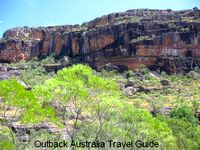
Like Ubirr Nourlangie is known mostly for its outstanding Aboriginal art sites. The art sites and a big Aboriginal shelter can be explored on a 1.5 km circular walk.
A short climb leads to Gunwarrddehwardde Lookout which offers great views over Nourlangie itself and over Kakadu's escarpment.
If you visit Nourlangie during the hotter time of the year you will immediately understand why these rocks were such an important shelter. They are a great place to enjoy one of the free ranger talks in the cool shade. Even on a still day you notice a slight breeze moving through the shelter. Try and imagine a tropical thunderstorm and torrential downpours. The huge rock shelter is well protected and would remain perfectly dry...
At Anbangbang Billabong you can enjoy a picnic or a barbecue at the picnic area, or a 2.5 km circular walk around the billabong with Nourlangie as a dramatic backdrop (check wet season access).
Other walks in the area:
- Barrk bushwalk: difficult 12 km circular walk. Allow 6 - 8 hours and read the Barrk Walk Park Notes first (available at the Bowali Visitor Centre).
- Nawurlandja Lookout: 600 m climb, views over Nourlangie, the escarpment and Anbangbang Billabong.
- Nanguluwur: 3.4 km return, walk through woodlands to quiet Aboriginal art site.
- Gubara Pools: 6 km return, sandstone cliffs and shady monsoon forest pools (check wet season access).
After leaving Nourlangie and continuing along the Kakadu Highway:
- Bubba walk: 3.5 km circular walk through several wetland habitats (check wet season access).
- Mirrai Lookout: moderately difficult, steep 3.6 km return walk to top of Mount Cahill.
Kakadu - Jim Jim Falls Area
This area can only be accessed in the dry season and only by 4WD.
The turn off is located 13 km past Mirrai Lookout, 43 km south of Bowali Visitor Centre.
© NTTC
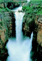
A 1 km return walk leads through monsoonal forest and over boulders to take you to the most spectacular of Kakadu's waterfalls.
Jim Jim Falls has a deep plunge pool and is surrounded by 150 m high cliffs. A steep walk (at least 4 hrs return) also leads to the top of the falls.
Now here's the drawback: the falls dry up during the dry season and the track is not accessible during the wet. That means the only way to see the falls in their full glory is to take a scenic flight.
(Jabiru Travel Centre: tel. +61 8 8979 2548).
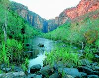
To reach Twin Falls in the dry season travel another 10 km from Jim Jim, and cross the deep Jim Jim Creek. The access to the falls is only by boat shuttle service, followed by a walk over boulders, through sand and over a boardwalk.
A steep 6 km return walk takes you up to a plateau above Twin Falls. Beautiful views and the pools along Twin Falls Creek make it more than worth the effort.
A 1 km return walk from the Jim Jim Creek picnic area to Budjmi Lookout provides views over the escarpment cliffs.
© NT Tourist Commission
For driving to Twin Falls car park from the highway allow 1.5 hours, then allow at least another hour for the return trip to see the falls. You can see, if you'd like to visit both falls and include a walk you definitely need to make a day of it. You could also consider camping at Garnamarr. If you have the time the trip is most definitely worth it. Even when the falls are dry, the scenery is still spectacular.
Kakadu - Yellow Water Area
About 6 km further on, 50 km south of Bowali Visitor Centre, you reach another strategic hub within Kakadu. The Gagudju Lodge Cooinda store sells fuel, gas, food, souvenirs and takes bookings. Accommodation is also available.
The Warradjan Aboriginal Cultural Centre contains a large display and video room and offers detailed information for those interested in Aboriginal culture in Kakadu. The gallery also sells arts and crafts.
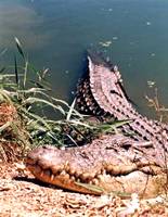
But the main attraction and the reason for the traffic in this area are the Yellow Water Wetlands.
The popular commercial boat cruises operate all year round and provide an excellent opportunity to view Kakadu's varied birdlife and other wildlife, including Saltwater Crocodiles.
Early morning or late afternoon is a good time for a cruise. It's the best time for viewing wildlife and the best light for taking photos.
You can also watch birds from the boardwalk (early dry season) or on the 1 km return walk to the viewing platform across the floodplains (late dry season).
Other attractions:
- Mardugal Billabong: 1 km return walk along the billabong edge.
- Gun-gardun walk: 2 km circular walk through woodlands
- Boat ramps are located at Jim Jim Billabong, Yellow Water and Mardugal Billabong.The water holes join up at the height of the wet season so boating between them becomes possible.
Kakadu - Mary River Area
The Mary River Roadhouse just outside the Southern Entry Station sells fuel, serves meals, and offers accommodation.
Kakadu's southernmost area is my personal favourite area for several reasons: it is the least visited part of Kakadu, it is closest to the highway which makes it easy to reach, and of course it is stunningly beautiful.
On another page I show photos and write in detail about the two main attractions in this area: Maguk and Gunlom. Both offer waterfalls, clear plunge pools and interesting walks. You will get a good idea of what it feels like to be there when you read the pages...
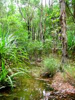 If you like bushwalking explore the Yurmikmik Walks. Four interconnected walks of different length (2, 5, 7.5, and 11 km) start from a car park about 21 km along the Gunlom road.
You will see many different habitats: woodlands, monsoonal forests, creeks and billabongs, all against the backdrop of the rugged ranges of the "southern hills and basins".
A great wet season experience, when some other attractions might be inaccessible.
Other walks and lookouts in the area:
- Gungurul: 4 km return walk from the picnic area along the river and up to a lookout for views over the South Alligator Valley.
- Bukbukluk Lookout: picnic tables and 400 m return walk, views over the old Goodparla Station.
Travelling the Northern Territory?
 The free Outback Pocket Guide
is a great introduction to travel in the region.
The full Top End Travel Guide 
shows you how to make the most of your adventure in Australia's tropical north.
NEW! Destination Red Centre is the latest addition in this popular series. Monica Coleman takes you through Australia's red Outback heart, offering all the detail and insider tips that you have come to know and love about our guides. With special emphasis on Aboriginal communities and culture.
A must have if you travel to or from Alice Springs/Uluru.
Main page: Kakadu National Park
Read about other National Parks in Australia

